
This summer has been characterized by dark, stormy clouds, coupled with frequent severe weather notifications doled out by Environment Canada— It might feel like we have been under a near-constant storm watch.
This year the Calgary area has received 12 storm watch notifications as of the writing of July 22. Eight of those 12 watches have materialized into storms.
The average number of storm watches in any given summer is between 10 and 15, and with nearly a month left in severe storm season, it looks as though 2020 has the potential to be above average.
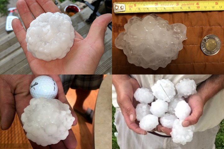
In terms of dollar-value damage caused by high-intensity storms, this year will certainly be above average, thanks to the June 13 hailstorm that ravaged northeast Calgary, causing more than $1.2 billion in damage.
“We’re already in that average range and we still have three to four weeks of severe weather season ahead of us,” said Blaine Lowry, Warning Preparedness Meteorologist with Environment Canada.
However, the frequency of recent storms may not necessarily be indicative of an overall trend towards more severe thunderstorms, Lowry said.
The typical severe weather season begins roughly around May long weekend and lasts until mid-august.
There are several criteria that a storm needs to meet before being classified as severe. Severe thunderstorms are storms that have the potential or are producing hail nickel-sized or larger, wind gusts of more than 90km/hr and rainfall of more than 50 millimetres in an hour.
“The last three summers have only had between six and 12 watches for Calgary, but when we look at 2016 there were actually 26 watches issued for the city,” he said.
The numbers between 2005 and last year, applying a 5-year running average to the data, signifies that the frequency of storms is consistently within the 10 to 15 averages.
Calgary has actually seen a slight downward trend in those 15 years, however that downward trend could be flattened if 2020 turns out to be an above-average, Lowry said.
Lowry noted, the frequency of storms is hard to quantify. Hailstorms, specifically, require someone to be present for the downpour and also to report the event to Environment Canada, unless the storm passes right over a monitoring station.
“Somewhere in Alberta, almost every summer, we get hail that size—tennis ball or larger. It’s just a matter of the damage that can inflict on an urban area is obviously more widespread. The infrastructure is more concentrated, that sort of thing. Versus a rural area where there can be crop damage, et cetera, but it might only impact one farm.”
For storms to become severe, several elements need to be at play at once. Cool air must be aloft to allow for convection and heat, moisture must be present in the atmosphere, and wind must be flowing to gather those elements together.
Lowry noted that a study done in 2012 called Severe Thunderstorms and Climate Change found contradictory elements at play.
“Basically what it comes down is, with a warming climate— Which we do have globally— there should be more heat and also moisture available in the atmosphere,” he said. “However, with the poles actually warming at a faster rate than the equatorial region… there’s been some research done to indicate that that weakens the flow of the jet stream.
“With the jet stream weakening, that actually lends itself towards less wind shear, which I mentioned before is the parameter that is required to organize these storms,” he said.
He added that the relationship between climate change and severe thunderstorms is inconclusive at this point.
“Basically, the research that’s been done on it to this point, in terms of climate change relating to a change in the severity of storms, the jury’s still out. There hasn’t been anything that’s been able to reconcile what is most likely, with this likely increase in heat and humidity, but likely decrease in wind shear to organize those storms.”
Lowry acknowledged that he hasn’t read all of the research done on the subject, but said that is the consensus among his colleagues currently.
After the record-setting storm on June 13 in northeast Calgary, a second hailstorm rolled through, causing more damage. While the residents of that area might feel like these storms are more frequent, Lowry chalks it up to “bad luck.”
Lowry said he had a colleague inquire with him regarding the area, and if northeast Calgary had any set of specific conditions that are causing these violent storms.
“Not really,” he said. “In this case, it was just bad luck. Both of those storms formed in other areas, intensified, and were the strongest over northeast Calgary.”
It is important to note that Lowry wasn’t discussing all severe weather events, only thunderstorms in this region. He did acknowledge that other types of storms and weather events could have different outcomes.
Another study from 2018, found that there was a “greenhouse warming-related increasing trend” associated with the effects of climate change on the jet stream, and associated that shift with devastating recent extreme summer weather events including the 2003 European heatwave, the 2010 Pakistan flood and Russian heatwave, and the 2011 Texas and Oklahoma heatwave and drought.


